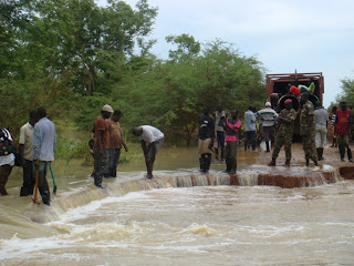
It's not just in Lakes State - right across South Sudan, access is a nightmare. People are stranded due to annual flooding that leaves the entire country in gridlock. Currently, Awerial County, the most eastern in Lakes State, is under water and 23,000 people have been displaced. In Upper Nile state, refugees are living in camps under water - but getting a reliable source of drinking water is almost impossible in some areas.
I was sent a map of South Sudan today from OCHA that show states and counties of South Sudan affected by flooding. It's rather grim. 29 of 49 counties are affected. That's 50%.
The yellow counties are those where emergency flood relief is ongoing. Almost all of Jonglei state is receiving flood assistance. Up in the top corner is Upper Nile state, where we are doing emergency WASH response for Sudanese refugees.
The road network all around the country is impassable in many places. Currently road access from Rumbek to Juba is almost impossible - on all three major routes. There is a country-wide fuel shortage which is being exacerbated by this situation; fuel comes in from Uganda and Kenya as South Sudan has no refineries, despite being a major oil producer (and currently the oil rigs are out of order due to ongoing North - South political conflict), but if the roads are not passable, no fuel can be transported anywhere. It also has wider ramifications for the transport of all other goods, particularly food - a majority of which is imported from Uganda. Prices in the market have sky rocketed, adding to the misery of locals already suffering from huge inflation. An apple in the market comes from Uganda (!) and costs 5SSP - which is over $1. Each one. In our case, we can't get WASH items such as parts for installing/repairing bore holes, or drilling rigs up to Lakes.
To illustrate my point, we received this update from UNMISS (United Nations Mission in South Sudan) today about the state of roads in Lakes State:
-->
UNITED NATIONS DEPARTMENT OF
SAFETY
LAKES STATE ROADS
CONDITION UPDATE
21 SEPTEMBER 2012
S/NO
|
ROADS
|
STATUS
|
O1
|
Rumbek-Wulu-Mvolo-
|
The road between RUMBEK-WULU-MVOLO is in a quite good
condition but still motorable at reduced speed.
|
02
|
Rumbek-Cuebeit
-Tonj
|
The road is
passable however with plenty pot holes
|
03
|
Rumbek-Yirol
Awerial
|
The road from AWERIAL to YIROL has many
road cuts because of strong water current. The government is working to fix
the road in some points
The road from YIROL to RUMBEK there is
many points on the road where the flooded water washed out parts of the road
especially between Yirol and Aluak luak.
|
04
|
Rumbek-Maper-Bentiu
|
The road is very
bad at the last 10kms to Maper
|
And some actual illustrations ...
Awerial - Yirol road
Rumbek - Yirol road

In Upper Nile, the road between Jamam and Gendrassa refugee camps was breached when I was there in August. This used to be a road ...
So, we wait. Wait for it to stop raining. Wait for the flood waters to recede. Wait for water to evaporate. Wait for road repairs. And wait for the proverbial shit to hit the fan when the fuel runs out.


No comments:
Post a Comment